Introduction
to GIS Course…(February 12,2018 to february 16,2018)- Register here as
individual or group-http://bit.ly/2DOyxuM
INTRODUCTION
GIS
is becoming an increasingly important tool in environmental management, retail,
military, police, tourism and many other spheres of our daily lives. If you use
a computer or a cell phone, you have probably already used a GIS in some form
without even realizing it. Maybe it was a map on a website, Google Earth, an
information booth or your cell phone telling you where you are. Proprietary GIS
software (software that cannot be freely shared or modified) is available that
will let you do everything we describe in these worksheets and a lot more.
However, this software is usually very expensive or otherwise limits your
freedom to copy, share and modify the software. GIS vendors sometimes make an
exception for educational activities, providing cheaper or free copies of their
software.
WHO SHOULD ATTEND
Individuals who are new to GIS (no
prior GIS education or workplace experience with GIS)
COURSE OBJECTIVES
Use
online resources to quickly create a GIS map.Describe
two common data models used to represent real-world objects and phenomena
in a GIS.Evaluate
geographic data for use in a GIS mapping project.Explore
a GIS map and access information about map features.Visually
analyze feature relationships and patterns on a GIS map.Create
queries to find and select features that meet specific criteria.Prepare
a GIS map to share information and present analysis results.
COURSE CONTENT
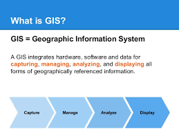
What is GIS?
How
a GIS worksWhat
can you do with a GIS?Discover,
use, make, shareIntroducing
an online GISUsing
a GISDefining
GIS
What is GIS data?
Vector
geometriesVector
informationRaster
basicsData
storageMetadataWhich
data to use?Choosing
data models
Navigating a GIS map
LayersScaleMoving
around a mapData
and layout viewMoving
around a map layout
Finding information
Info
tools and attributesAttribute
query basicsLocation
query basicsCreating
queriesQuerying
maps
General
Notes
·
All our courses can be Tailor-made
to participants needs
·
The participant must be conversant
with English
·
Presentations are well guided,
practical exercise, web based tutorials and group work. Our facilitators are
expert with more than 10years of experience.
·
Upon completion of training the
participant will be issued with Foscore development center certificate (FDC-K)
·
Training
will be done at Foscore development center (FDC-K) center in Nairobi Kenya. We
also offer more than five participants training at requested location within
Kenya, more than ten participant within east Africa and more than twenty
participant all over the world.
·
Course duration is flexible and the
contents can be modified to fit any number of days.
·
The course fee includes facilitation training
materials, 2 coffee breaks, buffet lunch and a Certificate of successful
completion of Training. Participants will be responsible for their own travel
expenses and arrangements, airport transfers, visa application dinners,
health/accident insurance and other personal expenses.
·
Accommodation, pickup, freight booking and
Visa processing arrangement, are done on request, at discounted prices.
·
One year free Consultation and
Coaching provided after the course.
·
Register as a group of more than two
and enjoy discount of (10% to 50%) plus free five hour adventure drive to the
National game park, in Nairobi.
·
Payment should be done two week
before commence of the training, to FOSCORE DEVELOPMENT CENTER account, so as
to enable us prepare better for you.
·
For any enquiry at:training@fdc-k.org or
+254712260031
·
Register as an Individual/ Group-
https://goo.gl/SajEYd
·
View GIS calendar 2018-2019 –
http://bit.ly/2DdrTky
·
View All Courses calendar
2018-2019 -http://bit.ly/2mB2p5w
·
Course Fee:KES:70000|USD:1000|EURO:900|POUND:800