GIS and Remote Sensing in Agriculture, Food Security and Climate Change Course
Click Here to apply for this course.
Agricultural mapping
Technological innovations and geospatial technology help in creating a dynamic and competitive agriculture which is protective of the environment and capable of providing excellent nutrition to the people. While natural inputs in farming cannot be controlled, they can be better understood and managed with GIS applications. GIS can substantially help in effective crop yield estimates, soil amendment analyses and erosion identification and remediation. More accurate and reliable crop estimates help reduce uncertainty. (Geospatial World, 2018)
Smart farming
Sensors in fields, on tractors and on satellites high above farms are constantly collecting data. Advanced technologies are able to turn this data into information that farmers and land managers can use to make more informed and timely decisions. This, in turn, boosts productivity and reduces environmental impacts.
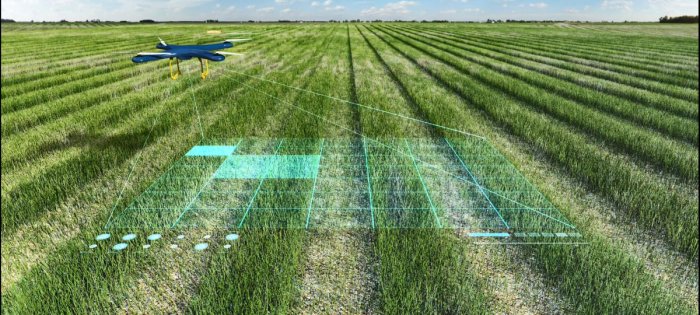
Farming is getting smarter with the availability of advanced technologies like precision equipment, the Internet of Things (IoT), sensors and actuators, geo-positioning systems, Big Data, Unmanned Aerial Vehicles, robotics etc. (Geospatial World, 2018)
Conclusion – Agriculture Technology
Precision farming, satellites, drones, web maps and sophisticated models – this list represents some of the agriculture technology that farmers and researchers use today.
The modern-day farmer needs to understand a lot more than just what to seed – soils, weeds, nutrients, weather, insects, disease, machinery and climate.
These emerging trends provide the location intelligence farmers need to get the job done faster and with more knowledge. (GIS Geography, 2019)
GIS and Remote Sensing in Agriculture, Food Security and Climate Change Course
To View Course Description and Outlines. Click here
Event Properties
| Location | Nairobi, Kenya | Kigali Rwanda |
|---|---|---|
| Event Duration | 10 Days | 10 Days |
| Event Date | 25-11-2019 | 19-08-2019 |
| Event End Date | 06-12-2019 | 23-08-2019 |
| Cut off date | 18-11-2019 | 12-08-2019 |
Browse more Popular GIS Courses Below.
Click on the course to view course details and to register
Course Organizer
Indepth Research Services is a capacity building institution, founded in 2003 with the objective of building capacity for development professionals to enhance effective delivery of development services in Africa.
The organization runs training programmes in East Africa, training over 10000 development
workers in the last few years.
DURATION AND COURSE LOAD: 2days to 10 days - 8 to 10 hours per week
PARTICIPANTS: Professionals
REGIONS TARGETED: Global
ORGANISERS: Indepth Research Services
GENERAL COURSE CONTACT: outreach@indepthresearch.org
Prior to the course start date, selected participants will receive, via email, an official invitation letter along with instructions on how to pay for the course. Course log on instructions will be emailed to you on the day the course is scheduled to begin.
Training Package offers Value for the Money. Training will be moderated by professional with hands on skills and great wealth of Experience.
Kindly confirm your participation with:
Online Training Coordinator
Indepth Research Services